
With the advancement of drone-based mapping, many people assume that taking a few hundred or even several thousand aerial photographs is enough, and that the processing software will automatically generate an accurate orthophoto. In reality, however, the process is far more complex. Even the most advanced photogrammetric software can encounter difficulties when dealing with certain types of surfaces, resulting in orthophotos that are incomplete, distorted, or even entirely unusable.
The root of the problem lies not in the number of photographs taken, but in the visual characteristics of the surface itself.
Photogrammetry uses patterns, not images
Modern drone mapping is based on Structure from Motion (SfM) and Multi-View Stereo (MVS) techniques. These methods identify common feature points across overlapping images and use them to calculate the camera positions and the geometry of the surveyed surface. A fundamental requirement of this process is that the software must be able to recognize the same point in multiple photographs.
These feature points may include:
– cracks in asphalt,
– rocks or gravel,
– road markings,
– patches of vegetation,
– building corners,
– high-contrast shadows.
The more unique details that can be identified in the images, the easier it is for the software to connect individual photographs and reconstruct the scene accurately. Therefore, photogrammetric processing is based not on the images themselves, but on the detection of recognizable patterns and matches between them. This principle is commonly referred to as pixel similarity or dense matching.
What happens on homogeneous surfaces?
Problems begin when the surface is too uniform.In the case of a freshly mowed lawn, a sandy area, a snow-covered field, or a large expanse of newly paved asphalt, much of the imagery looks almost identical. Under these conditions, the software cannot find enough unique feature points, making image alignment uncertain or error-prone. In the scientific literature, such environments are often described as featureless or textureless surfaces.
This issue is particularly well known in desert and sandy environments. A 2022 study specifically examined UAV imagery collected over homogeneous, texture-poor sand surfaces. The authors found that such conditions significantly complicate automatic feature detection and image matching, reducing the reliability of photogrammetric reconstruction.
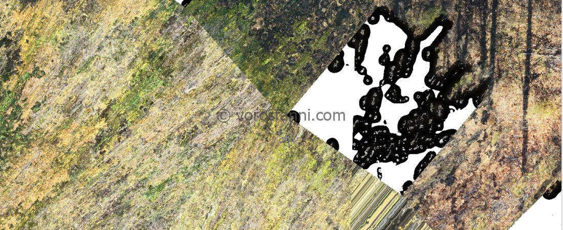
The same problem frequently occurs in forested areas. The image below clearly illustrates what can happen when surveying dense vegetation: these environments are among photogrammetry’s greatest challenges. Tree canopies lack a fixed, rigid geometry because they are constantly moving in the wind, while millions of leaves create repetitive patterns that are difficult to distinguish from one another. In this case, the pixel-matching algorithms were unable to identify sufficient stable reference points, leading directly to texture breakdown and the appearance of white gaps within the reconstruction.
Low sun angles make the situation even worse. Trees cast large shadows that can obscure significant portions of the terrain. Within these shadowed areas, the camera sensor may become underexposed, causing dark tones to lose detail. To the processing software, these regions often appear as uniform black patches. Since there is little or no contrast between neighboring pixels, the algorithm has no reliable visual information to work with. As a result, it effectively becomes “blind” in these areas and may either mask them out entirely or leave gaps in the final model, which typically appear as black regions or white holes in the orthophoto.

Water is one of photogrammetry’s greatest enemies
Water surfaces are particularly challenging for photogrammetry, and for several reasons. First, water often appears highly uniform, providing very few unique visual features that the software can use for matching. Second, the surface is constantly changing due to waves and ripples, meaning that the same location may look completely different just a few seconds later. Third, reflections and light refraction introduce additional sources of error into the processing workflow.
It is therefore no surprise that the photogrammetric processing of water surfaces and shallow underwater environments has become a dedicated area of research. Studies have shown that image matching performance can deteriorate significantly even when working with seafloor imagery that contains only limited texture. As a result, specialized algorithms are often required to achieve reliable feature detection and point matching under such conditions.
For standard photogrammetric software, water frequently represents a “moving target” where stable, repeatable patterns are either absent or obscured by optical effects. This can lead to gaps in the point cloud, geometric distortions, inaccurate elevation measurements, or complete reconstruction failure in affected areas.


What types of errors can appear in an orthophoto?
If the processing software cannot find enough common points between overlapping images, the consequences can be quite noticeable.
Common errors include:
– holes or missing areas in the orthophoto,
– misaligned mosaic sections,
– stretched or distorted objects,
– duplicated features,
– inaccurate surface models,
– wavy digital terrain models,
– georeferencing errors.
In many cases, the problem only becomes visible at the end of the processing workflow, when certain parts of the map assembled from hundreds or even thousands of images simply do not fit together properly.
What can be done?
Although homogeneous surfaces will always be challenging, the success rate of processing can be improved through certain methods.
These may include:
– reducing the flight altitude,
– increasing image overlap (80-90%),
– applying a cross-flight pattern,
– RTK or PPK positioning,
– the use of ground control points (GCPs),
– incorporating LiDAR technology where photogrammetry reaches its limits.
The effect of flight altitude is not straightforward. At lower altitudes, a higher level of detail can be achieved, while at higher altitudes more surrounding objects may appear in the images, which can assist image matching. The optimal altitude therefore always depends on the nature of the surface and the purpose of the survey. Studies dealing with homogeneous surfaces show that the geometric accuracy of models can be significantly improved, particularly when very high image overlap is used, even under unfavorable surface conditions.
Summary
The key to successful orthophoto generation is not the number of photographs, but the texture of the surface. Photogrammetric algorithms connect images based on unique patterns, which is why homogeneous surfaces such as water, sand, snow, or large expanses of uniformly colored pavement present significant challenges. Although modern software and precise positioning can help considerably, there are still environments where we reach the natural limits of photogrammetry. For this reason, a good drone survey does not begin with the flight itself, but with an understanding of what the camera will actually see on the surface.
Sources
Taha, A., Rabah, M., Mohie, R., Elhadary, A., & Ghanem, E. (2022). Assessment of Using UAV Imagery over Featureless Surfaces for Topographic Applications. Mansoura Engineering Journal, 47(1).
Elhadary, A., Rabah, M., Ghanim, E., Mohie, R., & Taha, A. (2022). The Influence of Flight Height and Overlap on UAV Imagery over Featureless Surfaces and Constructing Formulas Predicting the Geometrical Accuracy. NRIAG Journal of Astronomy and Geophysics, 11(1), 210–223. https://doi.org/10.1080/20909977.2022.2057148
Verykokou, S., & Ioannidis, C. (2025). Image Matching: A Comprehensive Overview of Conventional and Learning-Based Methods. Encyclopedia, 5(1), 4. https://doi.org/10.3390/encyclopedia50100
Micheletti, N., Chandler, J. H., & Lane, S. N. (2015). Structure from Motion (SfM) Photogrammetry. British Society for Geomorphology.
Muratbekuly, B., & Tynymbayev, S. (2025). Research in Structure from Motion and Multi-View Stereo Techniques in Photogrammetric 3D Reconstruction from 2D Image Sequences
Chen, Y., Le, Y., Wu, L., Zhang, D., Zhao, Q., Zhang, X., & Liu, L. (2024). Weak-Texture Seafloor and Land Image Matching Using Homography-Based Motion Statistics with Epipolar Geometry. Remote Sensing, 16(14), 2683. https://doi.org/10.3390/rs16142683
Maas, H.-G., Sardemann, H., Mulsow, C., Gueguen, L.-A., & Mandlburger, G. (2025). New Approaches in Photo-Bathymetry. ISPRS Archives.
Sardemann, H., Mulsow, C., Gueguen, L.-A., Mandlburger, G., & Maas, H.-G. (2024). Multimedia Photogrammetry with Non-Planar Water Surfaces – Accuracy Analysis on Simulation Basis.